Vertical Guidance Symbols
| Pseudo Waypoint | Definition | Conditions / Additional Info |
|---|---|---|
 |
Indicates top of climb | The FCU selected altitude (cyan) |
 |
A constraint altitude (if all appropriate modes are engaged) (magenta) | |
| Will not appear if the aircraft is 100 ft above or below selected altitude | ||
 |
Indicates level-off | The FCU selected altitude (cyan) |
 |
A constraint altitude (if all appropriate modes are engaged) (magenta) | |
| Will not appear if the aircraft is 100 ft above or below selected altitude | ||
 |
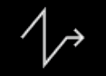
Indicates top of descent or continue descent. | Arrow is White if DES is not armed |
 |
Arrow is Blue if DES is armed | |
 |
Indicates start of climb | Arrow is White if CLB is not armed |
 |
Arrow is BLUE if CLB is armed | |
 |
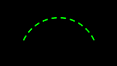
Indicates intercept point | Symbol is White if NAV mode is engaged |
 |
Symbol is Blue, if DES mode is engaged | |
| Predictions assume half speedbrake if above the profile | ||
| If vertical deviation is detected while in DES / NAV mode, continuously indicates predicted point where aircraft will intercept the descent path | ||
| If not in NAV, predictions assume immediate return to NAV path with 45° intercept | ||
 |
Indicates a speed change | Point on the flight plan where the aircraft will automatically accelerate or decelerate to a new computed speed |
 |
Indicates decelerate point | Predicted point on the flight plan where aircraft is predicted to decelerate for approach (and change to approach phase). Symbol is White if in selected speed or HDG/TRK mode |
 |
Symbol is Magenta if managed speed and NAV / Approach mode are engaged | |
 |
Set around a waypoint and indicates a constrained waypoint | Symbol is Magenta indicates predicted ALT CSTR will be satisfied |
 |
Symbol is Amber indicates predicted ALT CSTR will be missed |
|
 |
Symbol is White indicates ALT CSTR is not applicable and NAV mode is engaged |
|
 |
Indicates TIME MARKER or EQUI-TIME POINT (ETP) | Symbol appears in Green indicating on the flight plan where the aircraft will reach the time marker or ETP |
 |
Indicates the ENERGY CIRCLE symbol | Symbol is oriented to the current track line and centered on the aircraft position |
| (Energy Circle not yet implemented in the A32NX) | Indicates Required Distance to Land | |
| Displayed during descent and approach phase when selected HDG or TRK mode is engaged |
Also see our Example Managed Flight with several screenshots of the ND symbols during flight.